
Exploring Nothingness
By: Thomas M. Ciesla, April, 2008
|
|
|
An ephemeral Sun hovers close to the horizon, illuminating the surface with oddly colored horizontal light. As the team of scientists approach their preselected site, the landscape looks like the smooth surface of an endless bowl of milk. The pilot struggles to identify reference points in this milky whiteness and somehow manages to touch down safely. Once on the surface, the team works rapidly to deploy their outpost; they know that once darkness falls the conditions will worsen. As the light begins to fade, they pause a moment to take in the stark, frozen landscape before scrambling into their shelters. As darkness envelopes their camp (so dark you can't see your hand in front of your face) the temperature drops well below zero and the frigid winds begin to howl around them. Where are these men: Antarctica, the south pole of Mars, the surface of Saturn's moon Enceladus? Actually, it's none of the above. Traveling via icebreaker and helicopter in 2006, the team of four American and two Argentinean scientists [1]visited two enormous icebergs afloat on the Weddell Sea east of the Antarctic Peninsula. The team is part of the ICETREK cryosphere project, done in conjunction with the National Snow and Ice Data Center (NSIDC). Scientists recognize that the final stages of iceberg breakup imitate the rapid disintegration of Antarctic ice shelves due to global warming. Instruments placed on these icebergs monitor changes as the bergs drift into (relatively) warmer waters of the South Atlantic Ocean.
|
|
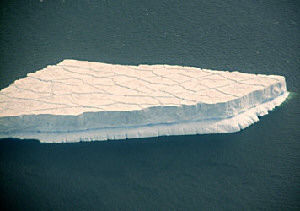
Figure 1: |
Unlike the icebergs popularized in movies, such as the one that sunk the Titanic, which tend to be small, clumpy masses, the Antarctic Ice Shelf icebergs, known as 'tabular icebergs', are vast expanses of flat ice. These ice-islands are usually 200 meters thick and often as large as some northeastern American states or small European countries, and lasting for years adrift in the ocean.
In 1995, an iceberg calved-off (broke away) from the Larsen Ice Shelf on the eastern side of the Antarctic Peninsula that measured 70km long and 25km wide. In 2000, when an iceberg calved off from the Ross Ice Shelf measuring 170 miles long and 25 miles wide – the size of the state of Connecticut – it caused a media frenzy around the world. A phenomenon known as “ice shelf disintegration”, that while more subtle in nature and less newsworthy, is far more devastating. In 2002, the Larsen B ice shelf – the equivalent to the size of Rhode Island – completely disintegrated into the ocean in 30 days. In February, 2008, the Willis Ice shelf, which is roughly 13,680 square km (5,282 square miles) began breaking up. Scientists believe that these events are directly tied to the warming of the Antarctic Peninsula. Fortunately, since all these events involved ice that was already floating on the ocean surface, there was no impact on sea levels around the world.
|
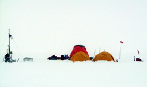
Figure 2: |
To better understand the lifetimes of these tabular icebergs, the ICETREK team boarded the icebreaker A.R.A. Irizar, departing from Marambio Station on the Antarctic Peninsula, heading east into the Weddell Sea, to place instrumentation on two of these bergs: AMIGOSberg and A22A berg. After smashing their way through ice fields some three meters thick at times, the Irizar arrived at the AMIGOSberg late on March 3rd, 2006, but fowl weather delays departure to the berg until the next day. In an unusually late 6 p.m. journey, the helicopter lifts off from the icebreaker and the team finally arrives at the iceberg. Here is how glaciologist Ted Scambos describes the landing in the Mission Log:[2]
March 6, 2006: |
|
After an early rise at 4:30 a.m., work continued deploying the equipment and Ted and another staff member ventured out to the iceberg's edge – a three kilometer trek one way. Upon their return from the edge of the iceberg,(see figure) the anxious crew of the Irizar dispatched a helicopter to retrieve the ICETREK team. They had spent less than 24 hours on the iceberg.
Roughly a week later, the ICETREK team repeats the process on a tabular iceberg island called A22A. They arrived at the iceberg at 5:30 p.m., March 18, set up base camp and equipment before turning in around 9:00 p.m. Mountaineer Rob Bauer writes in the mission log:
“As it was getting dark, we set up our two tents and crowded into the larger tent to drink tea and eat a little dinner. Temperatures were pretty warm during the night, around 9F, but the wind was rapidly building to around 30 knots.” Shortly after, the helicopter from the Irizar arrived to take them back to the icebreaker. “So, a full days work and well worth it,” according to Rob. | |
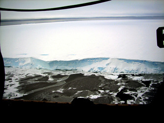
Figure 3: |
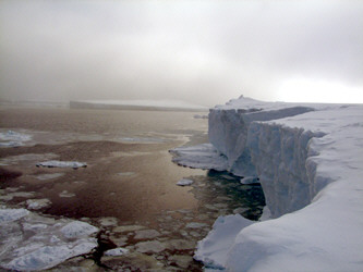
Figure 4: |

Figure 5: |
Why They Do It
Most scientists believe that Antarctica began to freeze over approximately 30 million years ago[3], and that the current ice sheet has existed for at least 3 million years (give or take). The floating ice shelves that surround much of the Antarctic ice sheet, undergoe cycles of growth and disintegration as part of the normal cryologic cycle of the area. Yet, there is evidence of startling changes underway in Antarctica and other regions of the world. The rapid retreat of smaller ice shelves on the Antarctic Peninsula may be linked to climate change. Since the 1950's, meteorological stations on the Antarctic Peninsula measured an increase in the air temperature of about two degrees Celsius. In that time, the Wordie ice shelf, Prince Gustav ice shelf and the Larsen A & B ice shelves have disappeared. While the ice shelves are not a direct influence on rising sea level change because they are already floating on the ocean, it has been argued that ice shelves help stabilize the land ice sheet in West Antarctica. Should all these ice shelves disappear, the glaciers behind them would accelerate to the coast and calve off into the ocean. This was underscored by Chris Rapley, head of the British Antarctic Survey, “Parts of the Antarctic ice sheet that rest on bedrock below sea level have begun to discharge ice fast enough to make a significant contribution to sea level rise.”[4] |
|
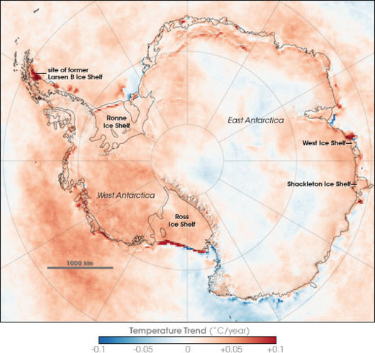
Figure 6: Between 1981 amd 2007, most of Antarctica warmed. Portions of West Antartica experienced a rapid rise in temperature as shown by the areas in red. (NASA image by Robert Simmons, based on data from Joey Comiso GSFC).
International Polar Year
For additional information visit these websites:
National Snow and Ice Data Center
|
Past computer models tended to focus on significant melting of the Greenland ice sheet while suggesting that the Antarctic ice sheet would remain more stable. However, a recent study of the George VI ice shelf on the Antarctic Peninsula by Dr. Mike Bentley of the University of Durham[5] shows that this currently 'healthy' ice shelf experienced an extensive retreat about 9,500 years ago, that coincided with a shift in ocean currents after a long period of warming.
A study used data from ancient coral reefs and Antarctic ice cores to reconstruct the climate during the last interglacial period, around 129,000 – to -116,000 years ago showed that the Greenland ice melt raised ocean levels up to 11 feet, but the total global rise in sea level was 13-20 feet. The most likely explanation is the impact of the Greenland sea level rise on the ice sheets of Antarctica, allowing glaciers there to break up and flow into the ocean.[6,7] Such a rise in sea level would threaten London, New York, Tokyo, New Orleans, and large parts of the Netherlands, Bangladesh and Florida.
The impact of climate change on the Antarctic region is not just about icebergs and sea level rise. The largest heat transport system on the planet is the thermohaline circulation (THC), a vast complex conveyor belt of deep ocean and upper ocean streams that distribute heat through the oceans. England for example, would be much colder if not for the effects of the Gulf Stream that brings the warmth of the waters around Florida to its shores. The THC is affected by two things: temperature and saltiness. Ice melt from sea ice and ice sheets in Greenland and Antarctica are major contributors to the flow of water around the planet. In warmer climates a change in the amount of sea ice and ice shelves would alter the amount of dense water supplied to the deep ocean currents, potentially shutting down some parts of the THC with disastrous results: changes in sea ice around Antarctica could influence the climates of countries half a world away.
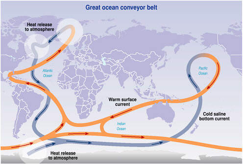 Figure 7: A simplified graphic of the thermohaline circulation patterns through the Earth's oceans. Melting sea ice (which is salty) as well as run-ff from glaciers determines the efficiency of the circulation. Another influence of climate change is the impact on the vast network of subglacial lakes [8] that exist under the Antarctic ice sheet. Helen Fricker[9], a geophysicist at the Scripps Institution of Oceanography, discovered a section of the inland Antarctic ice sheet that had dropped roughly 30 feet. As Fricker explains, “It's been know for a very long time that there are lakes under Antarctica's ice. There are 145 documented subglacial lakes and people are discovering more and more.” Working with scientist Ted Scambos of the NSIDC, Fricker realized that not only did they discover a new lake, but it was a lake that drained, thus dropped the ice above it. But where did the water go? It turns out that many of these subglacial lakes are connected to one another: as one drains it fills the next and so on, all the way to the coast. One negative effect of this of course, is that water lubricates the glaciers, allowing them to flow faster towards the ocean. The same is true when 'melt ponds' form on Antarctic ice sheets, then drain through crevasses to reach the bottom of the ice sheet. By placing weather stations and scientific instrument on the tabular icebergs, the ICETREK team helps scientists around the world to study an 'accelerated' breakup of an ice mass, that would otherwise take decades to wait for important data. These floating stations will resolve importance of basal melting versus surface pond melting and fracturing in ice breakup. Combined with information gathered by glaciologists and climatologists using data collected by land, sea and satellite, scientists hope to gain a better understanding of the cryosphere and the eventual impact on humanity. As these icebergs slowly disintegrate from the forces in the South Atlantic, the AMIGOS stations will meet their ultimate fate at the bottom of the ocean, having briefly served as paladins of science.
References
1. The ICETREK team includes glaciologists Pedro Skvarca (Institutio ntartico rgentino) and Ted Scambos (University of Colorado), Automatic Weather station specialist Jonathan Thorn (University of Wisconsin), video/computer systems expert Ron Ross (Stanford University), expert mountaineer Rob Bauer (University of Colorado), and mechanical engineer Juan Carlos Quinteros.
2. ICETREK Mission Log (2006) http://nsidc.org/icetrek/log.html
3. Baez, J. “Temperatures” (2006) http://mathurcr.edu/home/baez/temperature/temperature.htm
4. “West Antarctic Ice Sheet: Waking the sleeping giant” (2006) http://www.innovations-report.de/html/reports/earth_scinces/report-55525.html
5. British Antarctic Survey (2005, February 28). “Antarctica Ice Shelf Retreats Happened Before” ScienceDaily (http://www/sciencedaily.com/releases/2005/02/050224115901.htm)
6. Henderson, Mark (2006) TimesOnline, “London 'under water by 2100' as Antarctica crumbles into the sea.” March 24, 2006
7. Otto-Bliesner, Bett L., Marshall, Shaw J.; Overpecic, Johnathan, T,; Miller, Gifford, H and Hu, Aixue (24 March 2006) “Simulating Arctic Climate Warmth and Icefield Retreat in the Last Interglacial”. Science 311 (5768: 1751-1753, doi 10.1126/science, 120808
8. Lake Vostok lies roughy two miles below the Antarctic Ice Sheet. It is the size of Lake Ontario and 3,000 feet deep. Scientists believe that its waters have been isolated from sunlight and the atmosphere for millions of years.
9. Fricker, H.A.; Scambos, T,; Bindscladler, R. and Padman, L. (2007). “An active subglacial water system in West Antarctica mapped from space.” Science, 315: 1544-1548
|